MONITORING GEOGRAPHICAL COVERAGE
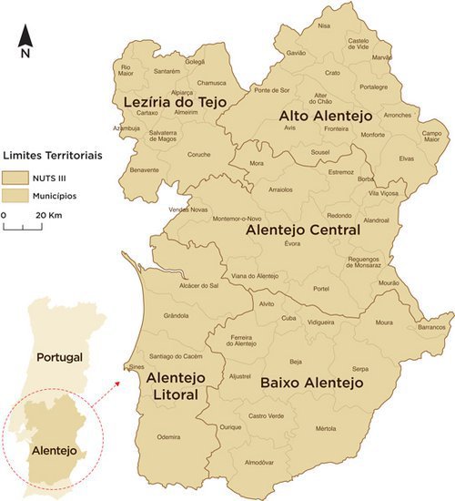
The monitoring of the tourist destination conducted by ASTO covers the territory corresponding to Alentejo NUT 2, which coincides with the geographical area of intervention of the Regional Tourism Authority Alentejo/Ribatejo. Briefly, the administrative division is characterised as follows::
|
|
ADMINISTRATIVE DIVISION |
|||
|
NUT 1 |
NUT 2 |
NUT 3 |
Municipality |
|
|
Portugal |
Alentejo |
Alentejo Litoral |
5 |
Alcácer do Sal, Grândola, Odemira, Santiago do Cacém, Sines |
|
Alto Alentejo |
15 |
Alter do Chão, Arronches, Avis, Campo Maior, Castelo de Vide, Crato, Elvas, Fronteira, Gavião, Marvão, Monforte, Nisa, Ponte de Sor, Portalegre, Sousel |
||
|
Alentejo Central |
14 |
Alandroal, Arraiolos, Borba, Estremoz, Évora, Montemor-o-Novo, Mora, Mourão, Portel, Redondo, Reguengos de Monsaraz, Vendas Novas, Viana do Alentejo, Vila Viçosa |
||
|
Baixo Alentejo |
13 |
Aljustrel, Almodôvar, Alvito, Barrancos, Beja, Castro Verde, Cuba, Ferreira do Alentejo, Mértola, Moura, Ourique, Serpa, Vidigueira |
||
|
Lezíria do Tejo |
11 |
Almeirim, Alpiarça, Azambuja, Benavente, Cartaxo, Chamusca, Coruche, Golegã, Rio Maior, Salvaterra de Magos, Santarém |
||
Territorial division of the NUTS 2 Region of Alentejo: NUTS 3 and Municipalities